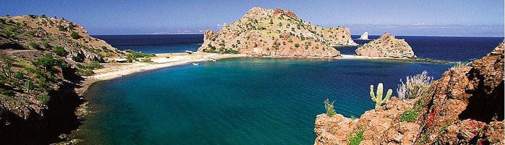
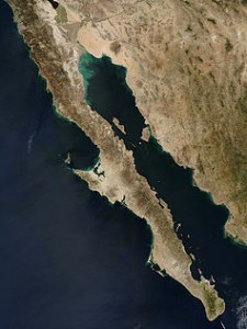
 The Baja Peninsula is located on the western coast of Mexico on the continent of North America. It looks like a splinter of land from the mainland of Mexico, starting at the U.S. border of California and Arizona and running south for about 800 miles. (See the map HERE!) The peninsula separates the Pacific Ocean on the west from the Sea of Cortez (often called The Gulf of California) on the east. At points, the peninsula is 140 miles wide and at others, it’s no more than 28 miles wide. There are over 100 islands dotting the peninsula and over 2500 miles of coast line! The deep, cold waters of the Pacific provide a rich ecosystem that supports a huge variety or marine mammals and sea life. Scientists sometimes call this area the “Aquarium of the World” for the rich variety of animals and fish that live here.
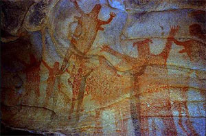 ANCIENT WORLD: Ancient paintings and carvings in caves along the Baja Peninsula show that the first people lived there over 10,000 years ago – about 8000 BC! When discovered by the Spanish in the 1533, the explorers thought they’d discovered a mythical land ruled by Queen Calafia whose, subjects were women from the Amazon who controlled huge amounts of gold and pearls. The Spanish sailors returned with hands full of pearls! Spanish settlements were quickly established in the late 1600s, but the country of Mexico didn’t gain its freedom from Spain until 1821 and at that time, the Baja Peninsula was still a territory. The Baja Peninsula was turned into a State in 1952 and has two regions, one called Baja California Norte and the other called Baja California Sur.
POPULATION: There are about 2,800,000 people who live in the Baja region today, of which 2,100,000 live in the major population centers of Mexicali, Tijuana and Ensenada. The other 700,000 people are scattered along the long length of the peninsula making this area a very wild and environmentally interesting region for exploration.
CLIMATE: The weather in the Baja Region is affected by the seasonal location of larger weather systems to the north and to the south leaving the peninsula with little rain. It’s a very dry, arid desert area—summer temperatures can reach 120 degrees Fahrenheit. Much of the year, the weather is caused by local conditions when western winds from the Pacific Ocean bring some rains that fall on the western shores, but then the air dries up crossing over the mountains which run like a spine down the length of the peninsula. These mountains are called the Sierra de Baja California. The highest point of these mountains and of the peninsula is Picacho del Diablo at 10,157 feet!
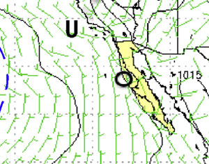 So, the western shores have a little more rain than the area on the eastern side and the Sea of Cortez. Many days, the bright sun warms up the dry land and with the Sea of Cortez being warmer than the Pacific, the warm airs rise upwards from the land and sea and that allows the cool air of the Pacific to flow in underneath, creating more wind during the sunny part of the day. These winds can definitely influence sailing.
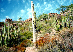 DESERT: The desert-like climate of the Baja Peninsula provides a home for types of plants like cactus and brush that need very little water to survive. The same conditions for animals make it attractive for animals like snakes and lizards, animals that are conditioned to hot sun and a dry climate.
FROM CABO NORTH: At the very southern tip of the Baja peninsula is the city of Cabo San Lucas. This is where the race that Bodacious IV is competing in will finish, and where we will begin our Bodacious Expedition. From Cabo, we will be sailing north along the coast going past Magdalena Bay, Cabo San Lazaro and through the Bahia San Lazaro before passing the town of Abreojos on the way to Turtle Bay. Because Bodacious IV is 52 feet long and the keel is 10 feet deep in the water (we call that 10 feet of draft), we will only be able to come into the harbor at Bahi de Tortugas…..or in English, Turtle Bay, which is about half way to San Diego or 400 miles north of Cabo San Lucas. In the months of March and April, when we are on the Expedition, we expect that the winds will be mostly “on our nose” … meaning that the winds will be directly in front of us so we might have to use the motor to go forward. If we do this, Turtle Bay is the only place we can get more fuel for the engine.
 WILD LIFE: The last trip I made through these waters we saw whales, dolphins, sharks, sea turtles, seals, along with many different fish and all kinds of birds. Whales swim through this passageway to and from their winter home in the lagoons around the Baja Peninsula where they give birth to their babies. At about the time we are heading north, the whales will begin their migration north as well to their feeding grounds in the North Pacific – so we surely hope to see a few whales. The most common type of whale in this area is the Grey Whale, as this is their breeding ground where they have their calves (babies.) We might also hope to see the Gargantuan Blue Whales, Humpback, Fins and Sperm and sometimes, even the rare Peruvian Beaked Whale. There are different types of Dolphins too. Most common in this area are the Bottlenose Dolphins, but we might see the two types of Common Dolphins….short beaked and long beaked. The long beaked are the ones most often seen playing in the path of ships and boats.
 Seals also like to play through the area and are often seen laying on their backs resting in the sun. Sometimes we’ll see them on their backs using their stomachs as a table to eat their fresh foods from – not so different from us lying in front of the TV eating snacks! There are also lots of sea turtles: Leatherbacks and Olive Ridleys that nest on the beaches, returning each year to lay their eggs on the same beaches where they were born! Hopefully we’ll see some turtles in the water as we sail by these beaches.
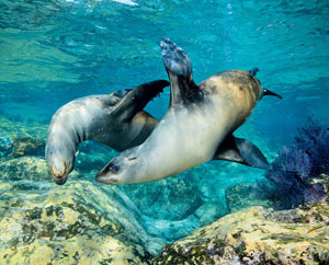
NORTH TO SAN DIEGO: When we leave Turtle Bay and head north toward Ensenada, Mexico and finally, San Diego, California we’ll cross Bahia Vizcaino and then go past Antonio and San Quintin before sailing past the city of Ensenada and then come up along the coast crossing the international border between Mexico and the United States through the Coronado Islands. Only 30 miles will remain of our expedition to San Diego at that point, but there’s still lots to see. Sea Lions are abundant in these waters, and are often seen on rocks sunbathing themselves.
– Dave Rearick (Bodacious Dreamer)