
(This is the second in a series of “Science Notes” from from our ocean scientist colleague, Tegan Mortimer, who works with Earthwatch Institute. These postings follow from encounters with nature that I have on the water. Tegan’s first Science Notes was on “Bird Migrations” – and can be found at the link or on our Citizen-Science Resource Page. Tegan’s Science Notes support our “Learning and Discovery” agenda, which we will keep expanding on over the course of the circumnavigation. Such “custom-made” reports we feel are particularly appropriate for sharing with the younger learners in your world. Please Contact Us if you have questions or suggestions on how we might better serve the interests of young learners and their mentors. Thank you, and take it away, Tegan!)
Today we’re going to talk about a very important topic; wind and weather. Dave spends a lot of time paying attention to the wind and weather patterns that control his journey. There are two types of weather patterns that Dave is confronted with: global weather and local weather.
Let’s start with global weather. These are weather and wind patterns which occur over very large parts of the globe and don’t change very much if they change at all. These are things like the trade winds and the doldrums.
So how does it work? Let’s start with the most basic concept of weather: warm air rises and cold air sinks. Understanding this concept is the first key to understanding weather and wind. Imagine that the air around you isn’t all this one big cloud of, well, air; instead it’s lots of pockets or parcels of air like cushions all packed together. By the way, this same phenomenon happens under the ocean with seawater as well as inside the earth’s core with magma.
Now, going back to the atmosphere, these different pockets can have different properties; different temperatures, different moisture contents and they can move independently of each other. A pocket that’s close to the surface of the earth is going to receive more heat from the earth than a pocket of air higher up in the sky. This warm pocket of air will start to rise and as it rises, it cools down until it reaches a point where it starts sinking again. This process than will start all over again as parcels of air keep going up and down. This movement of air upwards is sometimes called an updraft.
Now what does this all have to do with winds? First we have to imagine that we have a parcel of warm air at the ground. Like a balloon this air is going to rise, but as it rises, its temperature goes down. Eventually this air cools enough that it will start sinking back down. So we end up with our air going up and down over and over.
Let’s imagine this process of air rising and then sinking stretched over a longer distance, so that once the air sinks, it flows across the surface picking up heat until it rises again. The surface of the earth is covered by a series of these rising and sinking cells.
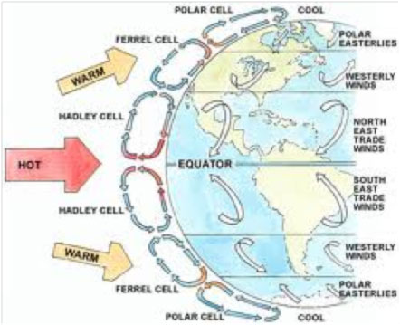
Source: wiki.flinthill.org
If we look at the diagram above we see that there are three major cell types. I’m going to talk about the Northern Hemisphere here, but it is exactly the same in the Southern Hemisphere – just flipped the other way! Hadley Cells transport air from the tropics towards the equator where it rises and is carried northward aloft. The Ferrel Cells cover the mid-latitudes and carry air which sinks at the tropics north to the Polar Cells which transport cold air south from the poles. This system helps to distribute the excess heat in the equator and tropics out to the mid-latitudes and polar regions.
What you’ll also notice is that this system of circulation gives rise to the major winds, especially the trade winds which Dave has been experiencing, and which are so essential to trans-Atlantic crossings.
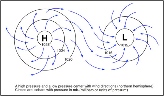
Now it’s time to introduce the second major concept: high and low pressure. When you have a steady stream of air rising, it’s not going to be able to sink back down because there is more air pushing up behind it; instead it flow outwards before sinking down again. Where the air rises and disperses is a low pressure and where the air converges and sinks is a high pressure. Air will always flow from an area of high pressure to an area of low pressure. This “pressure” concept is found throughout biology and chemistry as well.
If we look at the equator, between the two Hadley cells, we see that air is traveling towards the equator, rising, and then flowing outwards. This is a Low Pressure area. Conversely, when we look at the area between a Hadley cell and Ferrel cell we see that the air converges aloft, sinks and then flows outwards, this is a High Pressure. What this means is that there is a low pressure all the way around the equator, a high pressure around latitude 30° and another low around latitude 60°. Air naturally flows from areas of high pressure to areas of low pressure. When this is combined with the revolution of the earth you get the major winds.
 Source: rgsweather.com
You’ve probably heard about high and low pressures in your local weather reports too. High and low pressure areas occur when the surface pressure is either higher or lower than the surrounding “sea level pressure” which can happen for a variety of reasons. These pressure systems are responsible for most of our local weather. The same process that I described early is occurring here as well, a low pressure is air moving up and away and a high pressure is air moving down to the earth.
The GENERAL RULE is that air flows into a low pressure and away from a high pressure. In the northern hemisphere winds flow clockwise around a high pressure and counter-clockwise around a low pressure, and it’s the opposite direction in the southern hemisphere. Low pressure systems are usually associated with cloudy, wet, and “unsettled” weather while high pressure systems bring dry and clear conditions.
So, let’s finish off with a problem. Below is a picture of winds (taken from a very cool site) which are forming a weather system. Based on this map we can say a lot about the local weather. Are we looking at a high pressure or a low pressure? What types of weather are associated with low pressures? What types of weather are associated with high pressures? What do you think the conditions are like in the area shown?
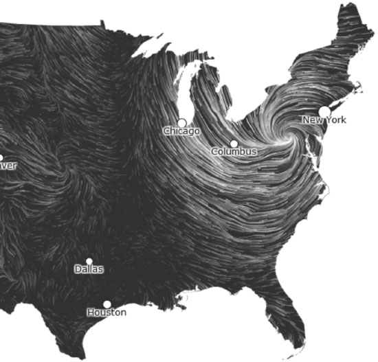
Let’s break it down based on what we’ve learned. So we are in the northern hemisphere so we can figure out if this is a high or a low pressure based on the circulation of the winds. They are circulating counter-clockwise which means that this is a low pressure. Another clue is that the winds are circulating into a tight center rather than out of an area like we can see to the left. The bolder lines on this map show stronger winds so we can see that there are strong winds around the low pressure and lighter winds around the higher pressure to the west. We also know that low pressures being rain and cloudy weather. So looking at this map we can say that most of the northeastern United States is experiencing rainy or stormy weather with high winds. In fact this is a map showing wind conditions during Hurricane Sandy last year.
(Tegan Mortimer is a scientist with Earthwatch Institute. Contact Tegan directly at Tegan Mortimer <tmortimer (at) earthwatch (dot) org>)