
Well, departure time is fast approaching and while it looks like we’re still on track to launch the circumnavigation next Tuesday, October 1st … there looks to be a big storm brewing out in the Atlantic that may delay us a day or so.
That said, I want to start by heaping thanks on Tim Eades for hanging in there with me as we work through the action list, gather pieces and parts, argue with people about time frames, hope for things to arrive on time and commiserate when special orders don’t arrive when expected. But, isn’t that what preparing boats (or ourselves) for life’s challenges is all about? And truth be told, we are having a ball – LOL at ourselves over here. I’m sure if you were here watching us from the pier, you’d be laughing too at our SDSS (Semi-Disorganized Sailor’s Shuffle!)
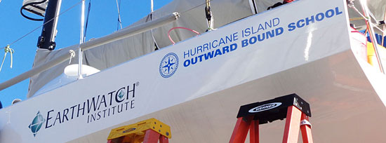
Everyday has its highlights too. The first of today’s “moments” was adding the new Hurricane Island Outward Bound School logographic up on the boat. Capt. Tim and I are getting pretty tight to the line there.
Even better was yesterday’s highlight … the arrival of Tegan Mortimer from Earthwatch Institute with a box full of scientific research tools for me to use during the circumnavigation.
Here’s a video of Tegan and I opening my box of new science tools. I would have been excited about it … even if there were no vacuum-sealed cookies in the box!
As you may remember (from a previous post,) Tegan is a science coordinator at Earthwatch, and she has been instrumental in bringing me up to speed on the research programs I’ll be contributing to when I’m traveling out into the “data sparse” parts of the oceans. It’s relatively easy to draw data from coastal and near-coastal areas, but in the open ocean, not so … hence, the term … ”data sparse.” While we travel through these areas, Tegan has outlined some ways that we can help to do our part in gathering scientific data … even if the tools we’re using aren’t quite as sophisticated as the ones full-on scientists use.
Tegan has also agreed to serve as a kind of go-to pro for your questions about the ocean. She has also begun to put together a great set of links to “Citizen Science” projects … some of which are specific to our Circumnavigation. We’re very excited about this! Thank you Tegan! You can find our evolving BDX “Citizen Science Resources” page HERE!
So, back to our training session … Tegan explained that we’ll be looking at three different areas in which to gather information. FIRST and easiest involve regular observations of animals, interesting phenomena and debris that we encounter. The great thing about this camera I have is that it geo-tags photos! So, if I see a whale … or some surprising debris, I can take a photo and it will log the GPS location, time of day and date, and that photo can then be analyzed by Tegan and other researchers and added to their geo-specific database of information.
 The SECOND area we are going to pursue involves taking samples of water and filtering them to determine the amount of micro-plastics and other microscopic types of things our samples contain. Research vessels have sophisticated ways of doing this, but since we’re more citizen-scientist than career-scientist, we’ll use a much simpler method. You can do this at home yourself if you like. It involves using coffee filters, a strainer and a measured container for water. I’ll collect a specific amount of water in a measuring cup; pour it into the coffee filter held over the strainer, which allows the coffee filter to strain out all the microscopic bits. I will then log and number these samples, take a photo of that sample so it is geo-tagged and email off the results. Easy as that! It will be interesting to see just what can be gained from inspecting these filters.
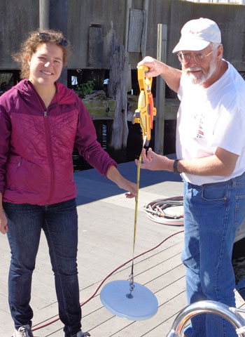 The THIRD area involves one of Tegan’s special interests, and that is measuring plankton with what’s called a “Secchi Disc,” which is a white disc, hung from a tape measure. The idea is to drop it into the water until you can’t see it any more … then once you make sure you have the proper depth, you lift it up until you can see it and then you drop it again until it disappears. You do this with the sun at your back and between 10 am and 2 pm, so the data is consistent. This same scientific method of determining water clarity has been in practice since 1865! Now, what’s cool is all this data can then be logged into the free Secchi app on my iPad and sent back to the researchers. This app (for Android too) is neat in that it will log my passage through these areas, what I found and where I was when I did so. If you check out the app, you will see that there is very little existent data south of the Equator where I am going, so I’ll be contributing some pretty rare first-hand research. Whoo-hoo for science! That’s another thing that makes this trip so much fun … is this exploring and discovering areas of the world from which research scientists very seldom get data!
So, THAT was yesterday. Today Tim and I are finishing up the installation of the hydro-generator, which is a pretty fascinating piece of machinery that I’ll talk about more in a day or two. So, for now, it’s back to work on the boat. Lots to do, but this afternoon I’m hoping to transit into “logistical” mode as the action list grows shorter … because it’s time to start packing gear and provisions onboard!
We’ll be getting more videos on Tegan’s visit up on our BDX YouTube Channel very soon … and when you get the chance, check out the above apps that we’ll be using. Maybe you and some friends would like to sample the water around your area. And sign up for the mailing list, why don’t you?
Again, huge thanks to Tegan for her enthusiastic help in getting our science program underway! I’m sure we’ll hear more from her as the trip progresses!
Until later,
– Dave, Tim, Tegan & Bodacious Dream