The Atlantic Cup Shares the Dream

cyclone_lusi_175
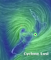
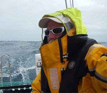
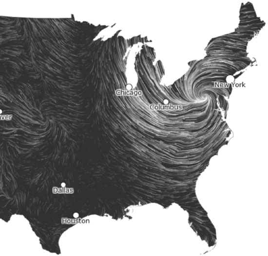
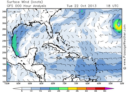
Here in Wellington, preparations for our departure are complete. Bodacious Dream is ready and waiting to take off on Leg 3 of our single handed circumnavigation, but as has happened before … weather considerations are conspiring to delay our departure! First there was a cyclone named “Lusi” that dropped down on us from up north and then another storm that also delayed our departure.  (You can view the state of the winds at any place in the world (and in near real-time) on the marvelous EarthWindMap website.)

Once the weather stabilizes, Bo and I will depart this lovely place and head east to a waypoint along Longitude 100 West – about a three-week sail from Wellington. Once there, we’ll carefully weigh all the seasonal weather projections and at that point make a final decision as to the prudency of either heading south and around Cape Horn as planned or instead heading north along the west coast of South America to the Galapagos Islands and from there onto and through the Panama Canal. Whichever way it goes, big decisions and big adventures await us. More on all of this very soon!

dave_iconIn the meantime, and in case you missed it earlier, we want to update you on a SUPER cool education initiative being undertaken by our good friends from the Atlantic Cup Race – 11th Hour Racing and Manuka Sports Event Management. 

After what I know has been a particularly harsh winter for many, springtime once again approaches … and as it does, thoughts of another sailing season begin to stir.

Atlantic CupFor the past two years, Bodacious Dream has started its season off by racing the Atlantic Cup, a challenging three-leg event up the Atlantic Seaboard, starting in Charleston, SC, with a stopover after reaching New York City before finishing up in Newport, RI for the inshore leg. With Bo and I being in the Southern Hemisphere, we’ll sadly be missing the fun this year.

I have many fond memories of the past two years, especially last year, where after winning the first two legs sailing double handed with Matt Scharl, I along with a stellar inshore crew held off an incredibly competitive fleet of challengers to win the overall event!

ac_bd_2013_550
That’s Bodacious Dream from last year’s AC … with the Jamestown FiSH sail!

Another exciting side of the Atlantic Cup is that the sponsor, 11th Hour Racing along with race organizers Manuka Sports Event Management, run by Julianna Barbieri and Hugh Piggin take a very active interest in providing educational opportunities to youth in the harbors into which the racers sail. We have always enjoyed taking part in these “Education Days,” as you know our abiding interest is to share the Bodacious Dream experience, just as we do now with our own educational aids for kids and teachers through our BDX website and Explorer Guides.

gulf_stream_ac_550Learning by raising questions from nature … 

Sharing our mutual interest in providing learning experiences for people and kids, the Atlantic Cup has chosen this time around to combine our efforts with theirs by utilizing some of our Explorer Guides materials to launch their own new KID’S PAGE this year. So, while Bodacious Dream will greatly miss competing in this year’s Atlantic Cup, (truly one of the top Class 40 regattas worldwide,) we are grateful that our presence will be felt in the content on the Kids Page of the Atlantic Cup Site. This chance to continue to influence and educate people and kids, (not to mention seeing myself represented as a friendly cartoon character) – is almost as big a kick and honor as winning the event itself.

Capt. Dave Education Guide
I guess I DO look like that! What do you know. Open their PDF by clicking on the above image.

This is only the latest turn in the story between the Atlantic Cup and Bodacious Dream. Last year, at the request of 11th Hour Racing, I drafted a blog post wherein I tried to capture some of what I have to know about learning and discovery. I titled it … If I knew then, what I know now … and you can find that by clicking on the link. In it I try to make that case that the true test of what you learn will not be a test score as much as it will be the tangible gifts that a new skill or awareness brings to your life and to your relationships with others. Ultimately, we learn best what we learn from each other. Give it a read if you like (and feel free to drop me a line.)

education_Day_550Matt Scharl and I try to stand up to tough questioning … during NYC “Education Day”

Beyond the youth education outreach of The Atlantic Cup, we also support their sponsor, 11th Hour Racing in their efforts to establish dynamic new platforms for “public” education that emphasize the responsible use of energy and resources in the context of competitive sailing. Through sponsorship of winning sailing teams and regattas, advanced sailing and production practices, they help improve the energy profile and performance of racing boats and increase the personal investment of sailors in the health of our waters.

seas-reg

Since the beginning The Atlantic Cup, sponsored by 11th Hour Racing, and run by Manuka Sports Management has endeavored to present the most environmentally responsible sailing race in the United States – with both racing teams and race management working together to create a fully carbon neutral event event and to continue to play a leadership role in redesigning sailing practices and sailing regattas for the 21st Century.

:: Atlantic Cup Kid’s Page :: 11th Hour Racing :: Manuka Sports

So, as I prepare Bodacious Dream for the final 12,000-mile homeward journey, I hope you will follow this year’s Atlantic Cup as well as check out and share their Kids page with the kids in your world. There will be more great information coming from them once the actual race gets underway, but this is a terrific starting point for our younger followers, and those who care about their futures.

– Dave and Bodacious Dream

:: BDX Website :: Email List Sign-Up :: Explorer Guides :: BDX Facebook

A Storm of Bodacious Videos

While maintenance and repair work continues on Bodacious Dream here in Wellington, I’ve found some time to review the many hours of Leg 2 video and photos I took on the voyage here from Cape Town, S.A.

big_wave_550
It’s a Very Wavy World Out There – 42.568808S, 120.320942E

As you may recall, during that 7000-mile leg, we encountered quite a few tenacious storms – or what the weather people call “strong frontal passages.” I compiled some video clips from some of the storms into two briefer and more watchable pieces. I did some simple edits on them … which is all I can manage at the moment. Maybe soon, we can do a cool edit, but even without a thrilling musical soundtrack, you should still be able to get a feel for what it’s like out there on the open ocean when the winds and seas are “up.”


At the same time you are experiencing loneliness and fatigue, you are also carried along by something both energizing and mesmerizing.

To remind you, these cold fronts blew up from the South (Antarctic) and progressed westward providing us with westerly winds that pushed us towards New Zealand. They generally announce themselves by a couple days of northwest wind, which then builds into the 30-knot range as the front passes through, after which the winds switch over to the southwest before gradually fading out.

Dave_Foulies_350One particularly interesting storm I wrote about previously, involved a spin-off of a low-pressure system from a cyclone, which teamed up with a passing cold front to amp up the winds and make our sailing a couple levels more extreme. While the strongest part of this front/low passed rather quickly over a 24-hour period, it was a week-long event of sailing as fast and as far east as we could to get in front of its path, so it could push us along instead of smacking us in the face. In the end, we did make it east of the storm, but just barely. During the height of the storm, we were clocking winds around 50 knots – and you’ll see in one of the video clips, the TWS (True Wind Speed) reading on the instrument panel showed gusts to 40 knots!


No matter how senseless and arrogant we humans are about using up the ocean’s resources and wasting its precious beauty, it’s hard not to think that it is the ocean that will have the final word.

While all of this seems a bit edgy to the uninitiated, rest assured that Bodacious Dream is designed and built to handle these conditions, and in fact, is much more adept at it than I am! It’s specialized and custom-built for such tasks, whereas we humans are generalists who must keep adapting by learning new tricks. At the same time that the tempest tosses you around like a toy, you can’t help but succumb to the storm’s seductive beauty. To be in the center of such oceanic intensity, all the while knowing that there is so much more potential scale and force there yet to be unleashed, is humbling to say the least.

Coming up next, in a few days, will be some video that shows another side of Earth’s majestic powers. I’m talking about the glaciers of South Island, New Zealand. Stay tuned for that, as I think my visit to the glaciers was one of the most awe-inspiring experiences of my life.

Hope you enjoy the videos. I have a lot more footage and will try to compile them into more videos for those of you that have the time to watch.

Thanks and more soon….

– Dave

P.S. As a bonus for those of you who consider yourselves “veterans” of the sea, I have included another video of around 6 minutes in length that is mostly me talking through a week of strategic adjustments that I had to make in order to deal with the storm.


A sailor’s way of thinking about storms

Tegan’s Science Notes #2 – Wind and Weather

(This is the second in a series of “Science Notes” from from our ocean scientist colleague, Tegan Mortimer, who works with Earthwatch Institute. These postings follow from encounters with nature that I have on the water. Tegan’s first Science Notes was onBird Migrations” – and can be found at the link or on our Citizen-Science Resource Page. Tegan’s Science Notes support our “Learning and Discovery” agenda, which we will keep expanding on over the course of the circumnavigation. Such “custom-made” reports we feel are particularly appropriate for sharing with the younger learners in your world. Please Contact Us if you have questions or suggestions on how we might better serve the interests of young learners and their mentors. Thank you, and take it away, Tegan!)

Today we’re going to talk about a very important topic; wind and weather. Dave spends a lot of time paying attention to the wind and weather patterns that control his journey. There are two types of weather patterns that Dave is confronted with: global weather and local weather.

Let’s start with global weather. These are weather and wind patterns which occur over very large parts of the globe and don’t change very much if they change at all. These are things like the trade winds and the doldrums.

So how does it work? Let’s start with the most basic concept of weather: warm air rises and cold air sinks. Understanding this concept is the first key to understanding weather and wind. Imagine that the air around you isn’t all this one big cloud of, well, air; instead it’s lots of pockets or parcels of air like cushions all packed together. By the way, this same phenomenon happens under the ocean with seawater as well as inside the earth’s core with magma.

Now, going back to the atmosphere, these different pockets can have different properties; different temperatures, different moisture contents and they can move independently of each other. A pocket that’s close to the surface of the earth is going to receive more heat from the earth than a pocket of air higher up in the sky. This warm pocket of air will start to rise and as it rises, it cools down until it reaches a point where it starts sinking again. This process than will start all over again as parcels of air keep going up and down. This movement of air upwards is sometimes called an updraft.

Now what does this all have to do with winds? First we have to imagine that we have a parcel of warm air at the ground. Like a balloon this air is going to rise, but as it rises, its temperature goes down. Eventually this air cools enough that it will start sinking back down. So we end up with our air going up and down over and over.

Let’s imagine this process of air rising and then sinking stretched over a longer distance, so that once the air sinks, it flows across the surface picking up heat until it rises again. The surface of the earth is covered by a series of these rising and sinking cells.

Global Wind Patterns
Source: wiki.flinthill.org

If we look at the diagram above we see that there are three major cell types. I’m going to talk about the Northern Hemisphere here, but it is exactly the same in the Southern Hemisphere – just flipped the other way! Hadley Cells transport air from the tropics towards the equator where it rises and is carried northward aloft. The Ferrel Cells cover the mid-latitudes and carry air which sinks at the tropics north to the Polar Cells which transport cold air south from the poles. This system helps to distribute the excess heat in the equator and tropics out to the mid-latitudes and polar regions.

What you’ll also notice is that this system of circulation gives rise to the major winds, especially the trade winds which Dave has been experiencing, and which are so essential to trans-Atlantic crossings.

Now it’s time to introduce the second major concept: high and low pressure. When you have a steady stream of air rising, it’s not going to be able to sink back down because there is more air pushing up behind it; instead it flow outwards before sinking down again. Where the air rises and disperses is a low pressure and where the air converges and sinks is a high pressure. Air will always flow from an area of high pressure to an area of low pressure. This “pressure” concept is found throughout biology and chemistry as well.

If we look at the equator, between the two Hadley cells, we see that air is traveling towards the equator, rising, and then flowing outwards. This is a Low Pressure area. Conversely, when we look at the area between a Hadley cell and Ferrel cell we see that the air converges aloft, sinks and then flows outwards, this is a High Pressure. What this means is that there is a low pressure all the way around the equator, a high pressure around latitude 30° and another low around latitude 60°. Air naturally flows from areas of high pressure to areas of low pressure. When this is combined with the revolution of the earth you get the major winds.

highs and lowsSource: rgsweather.com

You’ve probably heard about high and low pressures in your local weather reports too. High and low pressure areas occur when the surface pressure is either higher or lower than the surrounding “sea level pressure” which can happen for a variety of reasons. These pressure systems are responsible for most of our local weather. The same process that I described early is occurring here as well, a low pressure is air moving up and away and a high pressure is air moving down to the earth.

The GENERAL RULE is that air flows into a low pressure and away from a high pressure. In the northern hemisphere winds flow clockwise around a high pressure and counter-clockwise around a low pressure, and it’s the opposite direction in the southern hemisphere. Low pressure systems are usually associated with cloudy, wet, and “unsettled” weather while high pressure systems bring dry and clear conditions.

So, let’s finish off with a problem. Below is a picture of winds (taken from a very cool site) which are forming a weather system. Based on this map we can say a lot about the local weather. Are we looking at a high pressure or a low pressure? What types of weather are associated with low pressures? What types of weather are associated with high pressures? What do you think the conditions are like in the area shown?

http://hint.fm/wind/
http://hint.fm/wind/ 

Let’s break it down based on what we’ve learned. So we are in the northern hemisphere so we can figure out if this is a high or a low pressure based on the circulation of the winds. They are circulating counter-clockwise which means that this is a low pressure. Another clue is that the winds are circulating into a tight center rather than out of an area like we can see to the left. The bolder lines on this map show stronger winds so we can see that there are strong winds around the low pressure and lighter winds around the higher pressure to the west. We also know that low pressures being rain and cloudy weather. So looking at this map we can say that most of the northeastern United States is experiencing rainy or stormy weather with high winds. In fact this is a map showing wind conditions during Hurricane Sandy last year.

(Tegan Mortimer is a scientist with Earthwatch Institute. Contact Tegan directly at Tegan Mortimer <tmortimer (at) earthwatch (dot) org>)

Storm-Riding, Rain Squalls and Science

The last 36 hours or so have been a bit frustrating and a bit exciting too. On one hand, we’ve had little or no wind which has made the going slow and with little cloud cover, the days have been quite hot. On the other hand, we’ve been monitoring a growing tropical depression, which has developed into a storm called Lorenzo. Presently, Lorenzo is south and east of me, and the interesting recommendation this morning from our online naval guidance system, Commanders Weather is … “Let’s go try to catch it!”

Weather _LorenzoLorenzo appears to the right there …

STORM-RIDING: Now, I know that may not sound too smart … and in most cases it wouldn’t be. But in our particular case, and at this particular time, we are trying to get to a point where I can pick up the NE trade winds and ride them down to the waypoint where we will enter and cross the “doldrums.” (The doldrums, being the term for that low-pressure area around the equator where the prevailing winds are almost always calm.) So, in order to move forward, we need whatever wind we can get, and if I can use the cold front that is supposed to pass through today to push me in that direction, and so catch the outside bands of Lorenzo, then it can help pull me east, which is just what we want to do.

With tropical storms and hurricanes, there is never a truly good side to them, but what is considered the generally navigable quadrant is the forward left corner. So if the storm is moving, as Lorenzo is to the North and East, then the left forward corner is where Bodacious Dream and I can hitch a ride around the underside to the East. Guess we’ll have to see if this works or not. Right now, the winds from the cold front, which began to pass over us just an hour ago, are still less than 8 knots, but we expect them to build to 15 and maybe 20 later this afternoon. If that happens, I’ll sail those winds to the Southeast, and hopefully catch those outer bands of Lorenzo.

sunset1_550Sunset Passing …

WATER CONSERVATION: Yesterday, as the day went on, we had a squall pass over us. What a grand and refreshing thing it is to stand in the middle of the ocean in a fresh water rain! It’s easy to lose track of how important the little things in life are, until you don’t have them.

I have not discussed this before, but Bodacious Dream has no onboard freshwater shower, so cleaning up (or “bathing” – if you want to get real liberal with the term) involves using a bit of saltwater, followed by just a bit of fresh water on the face. I don’t want to use up too much fresh water for such purposes … as I’m never sure how much I’ll need for drinking on the trip to Cape Town. I also have to keep in mind, that I’m only into Day 6 from Bermuda of what is likely going to be a 40-day trip to Cape Town. So, the 60 gallons of fresh water I have will be pretty close to gone by then. I plan to drink or use up to 1 gallon a day, but we always want to take precautions in case something were to go wrong. What if one of the jugs springs a leak? What if I get a cut and have to wash it regularly … or who knows? What if the mast breaks and I had to drift across the ocean? What if? What if? What if? This is the song of the sea, and it is why the art of careful preparation is so important for extended adventures like this.

sail1_400
What I see when my eyes drift up …

CITIZEN SCIENCE: In my role as a fledgling citizen scientist, we’re taking regular readings for Earthwatch Institute. These include filtering water, observing debris in the ocean, watching for wild life, taking readings with the “Secchi Disc,” as well as using these updates to help educate people on the interesting ways of the ocean.

citizen_science_200

As far as debris goes, I’ve only seen two pieces of plastic so far. One looked like a storage box or container, the other some ort of plastic cylinder. I’m sure neither were buoys marking fishing nets. I’ve taken pictures of them with the geo-tagging camera, so they can be logged onto the iPad and when I’m next in port, I’ll upload the information to the research sites.

Take a look at our CITIZEN SCIENCE PAGE … it’s chock full of great resources, put together for us by our Earthwatch ocean scientist, Tegan Mortimer.

In fact, I heard from Tegan the other day, about that Yellow Rump Warbler that joined me onboard a couple hundred miles off the coast of New Jersey. Here’s what she had to say.

Screen shot 2013-10-22 at 2.58.11 PM“I’m happy to report that Dave’s bird sighting has been uploaded to iNaturalist and has had the species id confirmed which makes it a “research grade” observation. This means that it will be included in a global biodiversity database, which provides scientists and managers information about the distribution and movement of animals. So very exciting!

As unusual as this sighting seems, it’s actually probably a bird, which was on its fall migration from Canada down to the Caribbean, maybe got a little tired and caught a little ride with Dave to get a rest! Bird migrations are pretty interesting (and migration in general) so I’m writing up a little piece for some educational background on it.”

Thanks Tegan, we look forward to reading the piece!

So, enough for now. I have to get back to business here … and catch up on our gusty “friend” Lorenzo. Be back soon to tell you what happens.

We all know how spotty Facebook can be, so make sure you’re getting the major updates by signing up for the email list here! Thx!

– Dave & Bodacious Dream

Coordinates as of 12:30 UTC (06:30 CDT)
054.5947W, 33.3195N 
Our Speed Over Ground (SOG) – 5.5 knots.
Our Course Over Ground (COG) – 130 Wind speed – 8 knots.
Cookies left- Not enough!