The Atlantic Cup Race is coming up in sneak attack mode and Bodacious Dream is almost ready for it! Matt Scharl, my co-skipper, done planting his farm fields, is joining me here in Charleston today where we’ll spend the next few days before the start of the race on Saturday finishing our preparations and mapping our strategy to match the weather forecasts. The boats are all gathered now at the Charleston City Marina. I was one of the last to arrive, having been up the Wando River at the City Boat Yard where Bodacious Dream was cozied up for the winter and then undergoing maintenance.
Like a FiSH out of water …
With the maintenance completed, Bodacious Dream and I left the boat yard Wednesday morning and headed down the Wando River to Charleston. As you get close to Charleston, you come upon the famous Arthur Ravenel Jr. Bridge.
A pretty darn bodacious bridge …
Had my hand at a bit of photo fun as I passed under it, framing the bridge’s suspension wires with the rigging of the boat.
Once beyond the bridge, we went by the Charleston Maritime Center, which is where the Atlantic Cup Race will start at 2pm Saturday afternoon. From there, we glided around the corner to the City Marina where the other competitors are docked – flags flying and all! And right in the middle of them, the flag of our sponsor … Newport’s own, FiSH!
I had a chance to meet some of the new competitors this year and reconnect with old friends and fellow-sailors – what an incredible bunch of folks.
I hope you’re looking forward to this race and our next “expedition” as much as we are. We’ve got a whole new Atlantic “Cup” Coast expedition right here in place on BodaciousDreamExpeditions.com … with brand new “Explorer Study Guides” for you (and the kids) to check out. Actually, everyone can learn something on this trip … the Atlantic Seaboard is such a treasure of natural and historical wonders … and we tried to cram a bunch of that info into the Guides, which I’ll also be referencing in my daily updates.
A sample section from our “Environment” Explorer Guide …
Also, this past week, we outfitted Bodacious Dream with fast onboard satellite Internet (whoot!) … so expect more photos and videos along with insightful race commentary from the now well-seasoned duo of Matt & Dave!
You can expect three to four days of exciting racing on the way to New York City. Once the race starts, you’ll be able to track the competitors and check out the standings via the race tracker at www.AtlanticCup.org. And we’ll be keeping you up-to-date on what’s happening with us onboard Bodacious Dream on both of our Bodacious Dream websites as well as on our BDX & BD Facebook pages. On our BDX YouTube Channel and on Twitter too @BodaciousDream. Lots of ways to find us!
And of course, if you haven’t already, check out the polling page on the Atlantic Cup website where you can vote for your favorite team (hint … hint – you don’t even have to register – just click on BoDream!)
Well, it’s just about time now; the Atlantic Cup Race starts this Saturday! Bodacious Dream is in Charleston, SC getting the finishing touches of maintenance she needs to be as quick as ever, while my co-skipper, Matt Scharl gets the last of his corn and soybean crops in so he can join me in Charleston for the final preparations.
Atlantic Cup Trailer 2013 …
Just as we did last year, Matt and I will team up again against some of the best sailors in the world in this great American race up the Atlantic Coast. Our first leg, starting on May 11th, will be the 648-mile long run from Charleston, SC to New York City before heading onto Newport, RI. Once on the water, we’ll have to make tactical decisions on whether to venture out to the Gulf Stream and gain additional speed from the fast moving currents, or stay closer inshore where there might be more wind; this is always a tough decision. We’ll cross Cape Hatteras, known as the “Graveyard of the Atlantic” because of its epic history of forceful weather and unpredictable currents before determining our final strategies for approaching New York City. Last year’s race found us in pursuit almost all the way before settling into third position, finishing in New York City under the glow of city lights, the Statue of Liberty and the famous re-building of the World Trade Center.
AMap of the Race …
We’ll then spend a few days in New York City relaxing, doing a fun Pro-Am race and attending an interesting conference called “Living on the Edge: The Atlantic Cup Presents Coastal Communities and Climate Change.” Then on May 18th, we start the second leg which takes us out to a turn buoy off the coast of Virginia before heading north up along the coast and into Newport, Rhode Island. Those of you who stayed up late to follow last year’s finish on the tracker know what a nail biter that one was. We rounded the buoy in fourth place, and went with a clever strategy of Matt’s that took us out to where we were the furthest east boat of the fleet. The course and wind shifts put us into the lead going into Narragansett Bay where the winds and tide turned against us as we struggled to sail to the finish, while our two closest competitors made up time and ground on us. The best part though was that we still finished ahead of them and everyone else on that leg.
Again this year we will be sponsored by our friends at a great restaurant in Jamestown, Rhode Island named Jamestown FiSH. If you ever get the chance, go – complete comfort and style … with incredible seafood, great burgers and a knockout wine list. We thank them for their great support not only to us, but also to the Atlantic Cup which this year will name the finish line in Newport … “The Jamestown FiSH Finish Line!”
Also, this time around and concurrent to our race up the coast, we’ll also be conducting the second in our series of Bodacious Dream Expeditions! On our BDX website at bodaciousdreamexpeditions.com, you can track the race while at the same time augmenting the racing experience by discovering and learning more about the many wondrous natural and historical elements that make this particular course so legendary: the incredible Barrier Islands, the powerful force that is the Gulf Stream, the untamed weather of Cape Hatteras and the rapidly changing urban coastal environment around big cities like New York City.
For this voyage, we’ll have a whole new set of engaging and subject-specific Explorer Guides (for you to share with the younger folks in your world,) which are full of fun facts and interesting questions and problems to work out. Here’s how to Get Involved! So, set your compass and your calendar for May 11th and the Atlantic Cup … and join the expeditionary force!
(Oh … and don’t forget to go to www.AtlanticCup.org/poll/ and vote for your favorite team … we’re hoping it’s us again this year!)
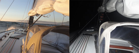
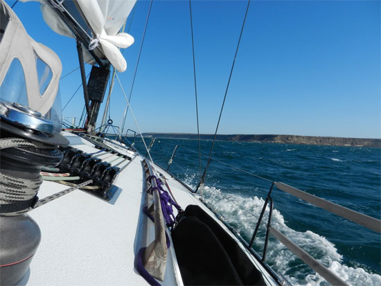
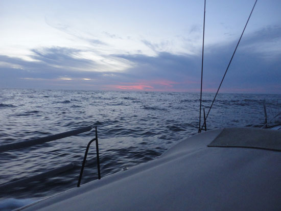
The heavy weather of last night subsided this morning and we got in a pretty pleasant day of sailing and making miles northward towards San Diego. “Heavy weather” is a sailor’s way of describing windy and wavy conditions. While the conditions weren’t actually stormy, we did spend a lot of time sailing in 25 to 30 knots of winds with ocean swells running as high as 3 meters (or 10 feet) … throwing thick spray into the air and water across the decks.
Day View/ Night View
As we get closer to San Diego, excitement builds among the crew in anticipation of the end of the passage. The Bo IV crew has been such a blast to sail with – right from the very beginning … but now, as we are approaching the end, we are all doing a lot of math trying to outguess each other as to how many miles we averaged over the last five hours, or what our average speed has been for the day, or what’s been our best distance made in 24 hours and of course, how many hours left until we finish. These are all fun things sailors like to do with numbers … that also underscore the need for them to have good math skills … especially if you are ever going to win any of these guessing games with your fellow crew members!
(So, have you figured out the difference between a knot and a mile per hour? That’s one of the bonus questions on our Explorer Guide for Math, if you want to check that out.)
QUESTIONS: Alongside questions of math, we have also had quite a few questions sent to us, that center on what goes on here, onboard a ship like Bodacious IV over the course of a near weeklong voyage.
For instance, people ask “How do we sleep?”“What we do at night?” “Do we stop somewhere?” “What do we eat?” “How do we stay warm?” Well, to each of those questions, there are various answers. So, let me respond to some of them.
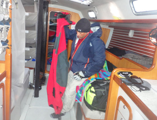
SLEEP:Typically, we sail all through the night without stopping. To do this, we break the night into two watches with each watch lasting three hours. After three hours, a new watch comes on and the old watch goes off to sleep for three hours. We sleep in what we call bunks or berths. These are narrow beds below decks and often at different levels, depending on the design of the boat. They are narrow, so that you don’t get tossed around in heavy weather conditions like we had the last few nights. This system works well for keeping people rested and alert when you are sailing over a longer period of days. Then there are other trips where you might stop every other night in a harbor, and so pass the time more leisurely. But even in those situations, there would still be a watch system to ensure that someone at all times is in charge of the boat and its safe operation. (You can see a few bunks in the photo below.)
Jonathan gears up for foul weather
FOOD/HUNGER:Eating is determined by a number of factors – the most important of which is having food available when you are hungry. But sometimes we have to wait until both crews are ready to eat, so that we can eat simultaneous to our changing watch. We eat primarily for energy, so depending on the level of work being called for, or how hot or cold the weather is, this can change what we eat and how often. When the weather is particularly rough, we often are only able to prepare sandwiches or snack foods. We steer clear of junk food as healthier whole grain breads, meats, fruits and vegetables give us more honest nutrition boosts and just a better and more energetic overall feeling. There is a good deal of math involved here too, as we calculate the energy, the food, the people and what their needs are, as each crew member has different dietary and calorie demands.
FOOD/ TEMPERTURE: Temperature also has a big impact on our diets. When it’s cold, people need to burn extra calories to stay warm … some people of course more than others. As we had heavy dew at night and temperatures down in the 40s, it wasn’t easy to stay warm, dry and alert when your body is trying so hard to find calories to burn. So you eat more when it’s cold out, so your body can keep burning calories and staying warm doing so. Can you see how important eating properly is and how math here too plays a role in the proper food fueling of a chip’s crew? And we haven’t even talked about cooking temperatures and times, and the math involved with doing all that.
To learn more about onboard nutrition, the video below is of an interview I recorded back in Cabo San Lucas with Chef and Master Provisioner Pierce Johnson (and noted nautical gourmand Jonathan Pond.)
Onboard Nutrition w/ Pierce and Jonathan
STAYING DRY & WARM: We also wear special clothes to help keep us dry and warm. Our base layers absorb the moisture from our body so that our skin feels less damp and wet. These materials are often a type of polyester mix of fabrics that have what are called “wicking” characteristics … meaning that they capture the moisture that evaporates from our bodies through sweat and transfers them to the outer layer of the cloth thus pulling moisture away from our bodies into an outer layer where it can evaporate. On top of those base layers, we wear fleeces and on top of those, our foul weather gear. In the old days, they used to just take cotton coats and soak them in wax or oil, so they would repel water when the waves and rain splashed on you.
Bring it on!
Modern technology has developed a range of materials that have such small holes in them that even the most microscopic part of water (when it’s in a liquid form like rain or ocean water) can’t penetrate through the holes. At the same time though, when moisture is in an evaporated (vapor) form, like the steam from a teapot or like your warm breath in icy air … that no longer liquid moisture can flow out through the holes. Water can’t get in, but vapor can get out! Pretty cool – or warm – depending on how you look at it. So, with these special clothes, we get the help we need in order to keep ourselves warm and dry in windy and wavy conditions – just like we’ve experienced the last couple of days.
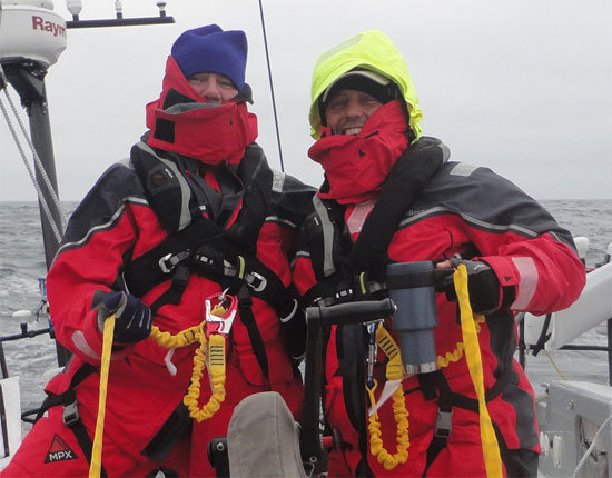
SAFETY: In addition to the foul weather gear, every crew member also wears what are called Personal Flotation Device (or PFDs.) These are automatically inflating life preservers that you wear like a jacket and that have built into then a harness and tether. We clip ourselves to the tether which runs the length of the boat, and prevents us from falling off the boat in rough conditions. Concerns for safety are obviously a very important part of our daily routine on the water. Respect for the power of the ocean must always be foremost in any good sailor’s mind. (In the photo below, Tim and Jonathan model the latest in PFD and tethering fashion.)
HEADING FOR HOME: We’ll be drafting more detailed summaries not long after arriving in San Diego … but a few words before we land. Knowing what an incredible area this is for whales, we really hoped we’d have seen some whales here the last couple of days, but we haven’t. I think it may well be that they don’t like the heavy weather any more than we do … and so stay longer in the calmer climes below the surface. We did have a lovely visit today from a seagull though. He flew right up behind me and landed on the corner of the boat, just to my left. He traveled with us for a couple of hours before heading off to who knows where. We always feel these moments are special when nature comes to visit us instead of us coming to visit it. Here’s a short video of that encounter captured by Heather.
A Seagull’s Visit
As to the bigger wild life, we never say never though here in the Bodacious Dreamtime; so we will continue to keep an eye out for more whales, dolphins and other wildlife on this last part of our trip.
Again … thanks for following along.
– Dave R., Tim, Heather, Jonathon and Dave H.
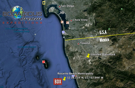
Time: 05:00 PST Coordinates: 32 18.714’ N 117 07.944’ W Boat Speed: 6.8 knots Course: 323 degrees
Well, it was quite the breezy day today out here Monday on the Baja coast. We’ve saw the winds spike as high as 30 knots and coming at us from various directions depending on how near or far from the coast we were. Such wind variations are caused by what are called “land effects.” What happens is that additional winds are created when the land heats up from the sun and the relative warmth compared to the coldness of the water causes a “thermal transfer” as the warm air rising off the land pulls in the cool ocean air underneath it. So, it’s been a day with a lot of back and forth, up and down depending on the winds and where we are! At the same time, the skies have been clear and the sun bright!
We have been seeing whales, but from a too far a distance for us to get any good videos of them. If you watch the horizon for a while though, you are sure to see them spouting … breathing out an upward gush of air and water. It truly looks just like the drawings or pictures in the books you read! In the three days we’ve been out here so far, on day one, we saw the one humpback whale wave its tail at us as we left the corner of Cabo San Lucas. Yesterday, we saw three whales while we were being entertained by a colony of seals. Today, we saw two spouts off our starboard (right) bow – but again, a bit too far away to capture in photos or videos. So, I’m going to say that was TWO whales too! We’ll keep a whale count and see how many we see through the entire trip.
Right now it’s a dark night and the moon has just started to rise. The stars are amazing as they always are, when you are away from the light of urban areas, where what is called “light pollution,” makes it difficult to see so many of the stars. The Milky Way, which is a swirling path of concentrated stars across the sky, was particularly brilliant tonight. Typically on dark nights, you also get to see phosphorescent plankton, but so far this trip, we haven’t seen any of it. I’m hoping that we’ll see some soon, and I can describe to you what we see … it is truly a beautiful thing nature shares with us …the plankton illuminate as the water is stirred up … like sparkles on a flowing black dress .
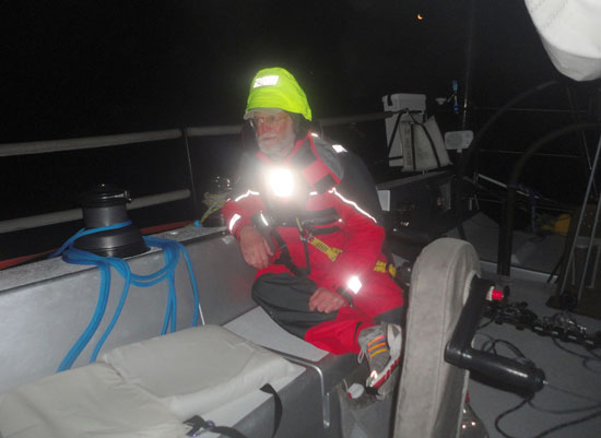
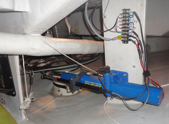
So, we learned another one of life’s valuable lessons today, which is to always check and take care of your equipment. Maybe it’s only your bicycle; or the brakes on your car, an important tool you need to do your job, or the computer you do your schoolwork on. For us today, it was the autopilot. It suddenly stopped working for us … and at a very bad time. The autopilot is a gizmo that uses a computer and a compass, to control a hydraulic rod that pushes or pulls to keep the boat going in a straight line. Late tonight, it stopped working just as we were rounding a point of land. Fortunately, I was at the navigation station at the time and saw the alarm, but it still took a few minutes for us to shut it off and steer the boat safely away from the point of land. What we discovered after crawling all through the back of the boat, was that one of the power leads was loose on its terminal. Once we got that corrected, it came back to life and we were back in business.
Here’s the autopilot, manually restored!
We’re all grateful to have it back, because with the wind and waves all stirred up as they were, standing at the wheel for long periods of time can get pretty uncomfortable. Imagine trying to concentrate on your job while someone is full-spraying a garden hose at you. So, always remember to check your equipment and make sure everything is working right before you head out on a bicycle ride or long car trip!
Dave & Heather – a small compass in her hand and a big one in front of the wheel.
There was a question posted to us on compasses, so in response, Dave interviewed the very knowledgable Heather on the subject. It’s great and informative stuff. Unfortunately, the audio w/the wind noise is a real challenge to understand … so, we didn’t post the video here … but, if you are the determined sort, it’s on our YouTube Channel … Part 1 of that interview is HERE and Part 2 is HERE!
So, that’s it for now. We hope we find and see more whales and maybe even some turtles in Turtle Bay on Tuesday when we stop and refuel there for the second part of our trip.
– Dave R., Tim Heather, Jonathon and Dave H.
Bodacious Dream Expedition Day #3 Position:
Position: 27 00.549′ N, 114 06.466′ W
Boat Speed: 6.2 knots
Course: 293 degrees
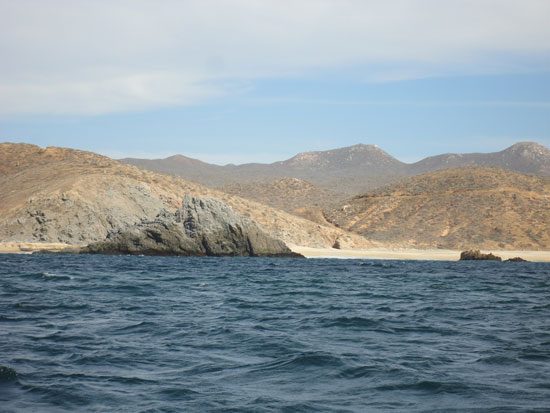
We untied Bodacious IV, Saturday at Noon, PST time and motored out of the Cabo San Lucas Harbor past many people vacationing and swimming among the beautiful beaches.
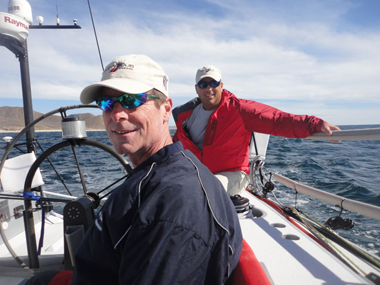
After finishing up final sorting and storing of the gear, as well as a final safety meeting, we got off to a good, but late start. While all five of us are very experienced sailors, we’ve never all sailed with each other before, and it’s necessary for safety purposes that we all have the same understanding of the procedures, so that should an emergency arise, we know not only where everything is, but also what each other is (or should be) thinking.
Just after we turned around the first corner and headed in the general direction of our destination San Diego, we were treated to a most wonderful site – a humpback whale surfaced and waved its tail at us as if to wish us off on a good trip! Unfortunately, we weren’t quick enough with the camera to capture it, but we certainly are planning on seeing more whales along the way. It was difficult to tell the length and size of this humpback, but we know they are generally 39–52 ft (12–16 meters) long and weigh approximately 79,000 lbs (36,000 kilograms) They are famous for their songs. (Do you know how long they typically live? You can find the answer in our Wild Life Explorer Guide.)
We were also visited by a school of dancing porpoises and a large turtle, but again, it was difficult to get the cameras on them. We’ll be quicker and better prepared for the next round of visits!
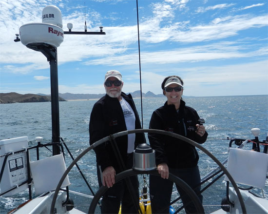
Meet a few of the crew: Dave Hardy (Engineer) & Jonathan Pond (IT Specialist)
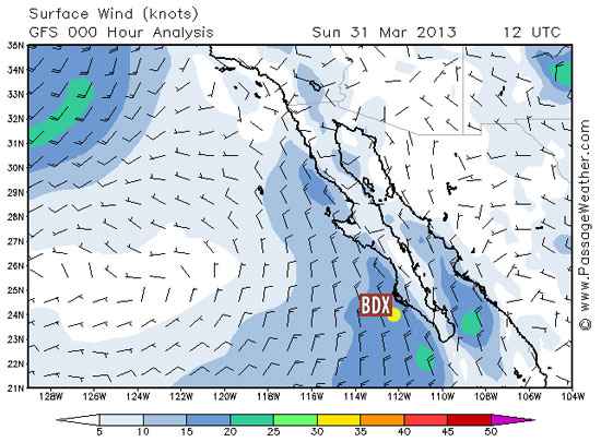
It looks now like the wind is going to be against us for most of the trip. That is going to make it more difficult than we’d hoped to sail, and we’ll most likely have to motor much of the way. There is a high pressure system moving north of us off San Diego, (the dark blue and green in the upper left corner of the wind map below) which is producing winds that circle high pressure in a clockwise direction. With the high pressure pushing from the left and in front of us, those winds will come down directly on our bow, and so act to push us away from our destination.
The moon rose behind us last night, as we were about 60 miles south of Magdelana Bay. We’ve been told by other sailors that know this route and these waters – to stay relatively close to the shore to stay out of the worst winds and waves. It does seem to make the trip smoother to be in about 60 feet of water.
So hopefully, the new day will allow us to get some video. In the meantime, If you care to, go ahead and ask us some questions. To do that, just go HERE and fill in the form.
And to all of you … have a lovely and peaceful holiday!
– Dave R., Tim Heather, Jonathon and Dave H.
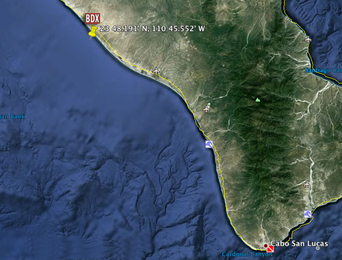
Bodacious Dream Expedition Day #1 Position:
23 48.191′ N, 110 45.552′ W
Course 319 (Angle on the 360 Degree Compass (more on that soon)
Captain Dave Rearick of Bodacious Dream visits and spends some time with Captain Ann from the nautical chart store, Sea Breeze Limited in San Diego – http://seabreezelimited.com. They discuss the Baja Peninsula and look at some other great and beautiful charts, as well some that will be used for the first upcoming Bodacious Dream Expedition of the Baja Peninsula – beginning on March 29th, 2013. For the longer version, go here … http://youtu.be/nqWgE_U-B18