
 WEATHER is without question the most essential variable in our getting to and from wherever it is we want to go on the water. High pressure systems, low pressure systems, troughs, omega blocks … all these terms refer to things that remind me of those blobs in a Lava Lamp! There are all around us these great bubbles of air masses that move about, pushing and blocking or sometimes combining to create bigger blobs that move their way through and around the Earth’s atmosphere. Certain areas of the globe constitute more definable weather regions where scientific measuring instruments are used to predict – with some fair degree of accuracy, how different winds and weather systems will behave over time. Still, in spite of constantly improving tools for data gathering, it remains a fairly complicated and uncertain science.
On an expedition such as ours, where we’re traveling through so many different weather regions, a lot of time is spent planning a route that avoids the worst of the weather. In a perfect world, we would love to leave harbor in fair weather with a following breeze (a breeze that’s from behind and not on the face) and route ourselves to avoid areas of bad weather and no wind. Racing sailors don’t get the luxury of choosing when to depart – races start and are sailed regardless of the weather that’s encountered along the course —adding an edgy and challenging element to the sport.
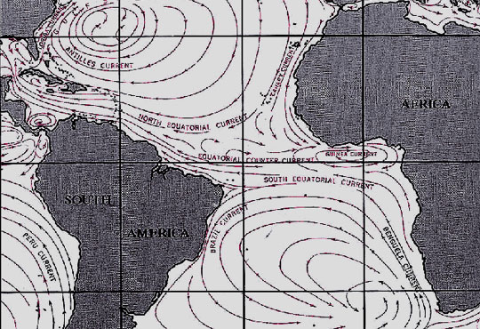
This part of the Atlantic Ocean where we are now, is a very complicated weather region and especially at this time of the year … with the Northern Atlantic entering winter while further south, hurricanes are being generated off the African coast. As the North Atlantic edges into the fall and winter season, the weather systems move from North America towards Europe. Then, south of us here in Bermuda, is an area called the “doldrums” – more technically called an “Intertropical Convergence Zone,” where there is little or no wind. Farther south of that, the trade winds blow from Europe and Africa to the west towards North America, and occasionally bring with them tropical waves, which can build into tropical depressions that can further intensify into hurricanes. Hurricanes, as we well know, can take on a life of their own sometimes, spinning around before being swept up into another increasing pressure system … or not finding one, then dissipating altogether. While some of this is predictable, beyond five days it’s very difficult to forecast specifics with any accuracy.
My trip to South Africa will take over 30 days, so making weather decisions with only a few day’s accuracy can be difficult and unsettling sometimes. But that said, this IS the conversation that sailors have always had with the sea. It is the encounter with nature as she is, and thus something you must adapt to if you are going to venture out into open water.
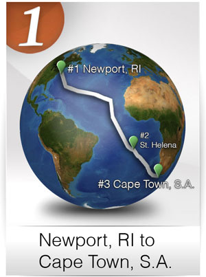 This time of year is not the easiest time of year to be making this passage into the South Atlantic, but if done with some caution and an eye (and ear) open to sound advice, a safe passage can be designed. Personally, there is this strange adjustment that I need to make to change my land-based and goal-orientated state of mind to the more flexible and patient approach better suited to life on the water. As I write this, my mind is focused on Leg #1 of the circumnavigation and on trying to get to St. Helena Island and then onto Cape Town, South Africa before Thanksgiving … but here I am in Bermuda, unexpectedly now for four or five days.
So, flexibility and patience require me to weigh all alternatives, one of which may be skipping St. Helena Island altogether and sailing directly to South Africa. The reason for this is that the winds this time of year are coming directly from St. Helena, which would require a lengthy, upwind sail which isn’t ideal or comfortable in a vessel like Bodacious Dream. A more traditional approach would be to sail across the trade winds on a more comfortable southerly angle until you get below the winds from St. Helena Island and there pick up the prevailing winds that blow from the west and towards Cape Town.
My own basic knowledge of weather was formed in predicting the strength of storms and winds in the Great Lakes region, but when considering more complicated sailing regions around the world, I need more experienced help. I use a service called Commanders Weather, to help me predict and plan my routing. Presently, we are looking at a nice weather window for leaving Bermuda on Friday or Saturday, but then after a couple of days, the winds are expected to diminish, which may well leave me sailing slowly and somewhat vulnerable to a couple of tropical waves that may (or may not) develop into depressions that might conceivably strengthen into hurricanes. So for the moment, I am waiting to get the most current weather analyses, so I can feel confident that I am making the soundest decision I can.
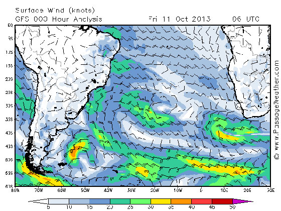
I’ve included a few screenshots here from another site called PassageWeather.com that show some of the options I am considering.
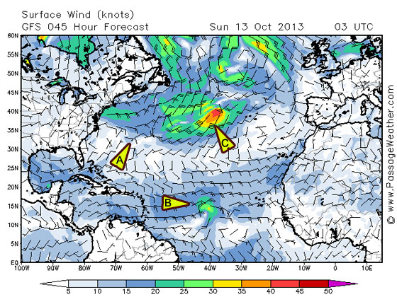
Let me TRY and explain what you’re seeing here. Triangle A is Bermuda with light winds engulfing it. Triangle B shows the development of the tropical wave in the band of wind to the south, which may or may not grow in intensity. Triangle C is the circle with darker green, yellow and orange that shows winds that have already intensified.
So, bottom-line here, what these shots indicate is that the best route with the winds behind us, would be to head down along the Brazilian coast and then swing east under the empty area keeping ourselves aligned with the winds pointing in the direction of Cape Town.
I know this may be new stuff for many of you … but I include it (and in some detail) because it is such a big part of what makes this whole expedition so amazing. As navigating sailors we must align ourselves with these dynamic current and climate shifts, as they are the forces that propel us forward … as well as what constantly renews and refreshes life on our planet. These seasonal and cyclical changes bring renewal to Earth’s bio-systems, affecting all various levels of the ocean’s food chain, which thus support the migration patterns of whales, birds and other marine life.
While we humans may have a say in deciding just when we weigh anchor, once we do, we are as much a part of that migratory process as the rest of nature. In the world, and especially on the water, everything is a part of some larger flow, and we are no exception.
– Dave and Bodacious Dream
A Green Flash – Circumnavigation – Day 04
Saturday’s sunset was a unique one. A much talked about natural phenomenon on the water is called the “Green Flash.” This happens when the sun sets into the sea, when the air at sea level is super saturated with moisture, which causes a refraction of the light and for an instant as the sun drops into the sea, it flashes emerald green. I’ve seen this once before in my life, and tonight I saw it again. I looked out at the sun and noticed it had a special brightness to it as it got close to the water. I grabbed for my camera and took a video of the final moment, and though it’s not so obvious in the video as it was in person, here’s what it looks like. Even if it just looks to you like another sunset, it was still an especially beautiful one.
A “Green Flash” (34 18.06 N, 66 33.96 W)
As we head south on a course for Bermuda, a few noticeable changes occur. First of all, you pass through the Gulf Stream. Now, if you were following along during the Atlantic Cup, we talked a lot about the Gulf Stream then. It is essentially a river of warm water that flows up along the eastern seaboard of the United States. (There’s an earlier Explorer Guide that looks at the Gulf Stream right here!)
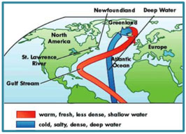 It’s interesting when you enter it or cross it as a number of things happen. First of all, everything gets warmer … the water gets warmer and so does the air. Next you see things like flying fish and Sargasso grass – things that ancient navigators used to help them know where they were in the world. Another thing about pushing further south is I’ve seen more ship traffic today. There were five ships in the last day and one close enough that I had to slow down to let him pass so we wouldn’t collide! These ships leave from the large, warm water ports of the southern U.S. headed around the world. Though at times I think I’m the only one out here, that’s never the case.
Presently, Bodacious Dream and I are about 110 miles NE of Bermuda. The weather has been very calm all day with very little wind to fill our sails – most of it less than 5 knots and coming from directly behind us. So, I’ve been motoring with the sails up and calculating how much fuel I’m going to needed to make Bermuda before sunset on Sunday. This is where knowing some math really comes in handy.
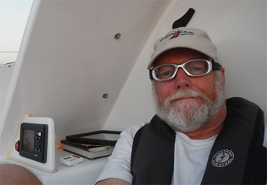 Sitting in my onboard “office.” (34 18.06 N, 66 33.96 W)
Let me share my current math problem as an example.
As I write this, it’s 23:00 hours on Saturday with 110 miles to go to get to Bermuda. The sun sets at about 18:00 hours on Sunday, so I have 19 hours to get to Bermuda before the sun sets and I can still see my way into an unfamiliar harbor. Now, Bermuda is a large coral island so there are many reefs and channels to be followed making it complicated and difficult to navigate at night … especially when alone. So prudent seamanship would have me enter the harbor during daylight hours.
 So, back to the math … 110 miles divided by 19 hours is about 5 and ¾ miles per hour. If I can sail at 4 miles per hour with the light wind, and use the engine to boost my speed up to 6 miles per hour, I should be able to make it in time. It takes 2200 RPMs (revolutions per minute) to have enough boost to make 6 knots, and at 2200 RPMs, I burn about 6/10ths of a gallon an hour of diesel fuel. I have 10 gallons left. Will I make it? Or will I have to stop using the engine and slow down and look to arrive on Monday morning? I’d like to be in on Sunday, so I can be ready to get some answers to my boat problems first thing on Monday. I’ll let you work on that one for a bit, while I go coax the wind gods into giving me stronger winds in my sails.
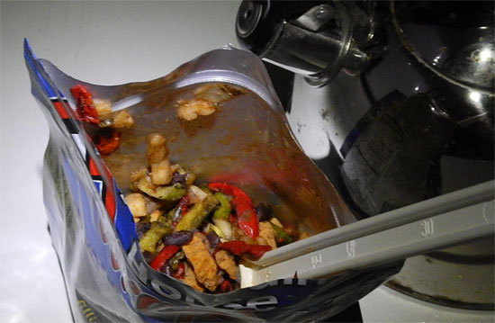
If you’re hungry enough, it’s good.
So, with all this happening, it’s now late and I’m hungry … so I’m making up a freeze-dried mix of Chicken Fajitas mix for dinner. (Let’s just say, no one ever did a solo circumnavigation because of the cuisine.) Anyway, typically I’d put this in a tortilla … but in the rush, I forgot to buy any of those, so maybe that’s on my list for Bermuda too!
More soon,
– Dave and Bodacious Dream
33 06.7491 N, 065 38.6709 W as of 08:22 EST
A Short Delay Before We Get Away!
Well, as sometimes happens … things get a little sticky when the time comes round to depart!
The wizardly Jonathan Pond was visiting here with me over the weekend and we went through a checklist of our various electronic issues to make sure that everything was in order with the satellite communications, computers, Iridium phones and all that electronics magic that is sometimes my arch-nemesis.
Well, as you might guess, we ran into some issues – this time with the Iridium phone, its charger and connecting devices. The Iridium is our fall-back communications system. The connection is supported by 66 low-Earth orbiting (LEO) cross-linked satellites, which operate as a fully meshed network … which basically means it works just about everywhere, but at fairly low bandwidth. We’ll use our KVH Tracphone V7ip unit for higher bandwidth communication when we are in satellite range to make that work.
Anyway, we are having the new equipment shipped in today … but this is going to delay the departure until Wednesday morning. Wish it wasn’t so … but these are critical components to the operation.
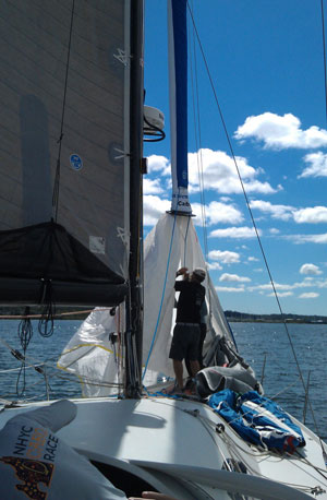
On the upside though, we were able to get out yesterday to test some sails, as well as the hydro generator and we also get some video footage out on the water. The hydro generator worked well, the sails are looking good and everything else seems to be coming together.
So, stay tuned….we’ll be heading out soon!
– Dave and Bodacious Dream
Trans-Pacific – Day #11 – 100 miles to go!
Day #11 arrives and it finds us in the Islands! 100 miles to go … and we are now into the final hours of the race!
We sighted Maui in a distant haze about 4:30 PM Sunday, and at this point, have passed along most of its length. We seem to be continuing to add miles to our lead, as our Division 6 cohorts all begin to converge on Oahu. Naturally, we’re hoping the winds stay fair for us, and that our navigator extraordinaire John Hoskins and his grand strategy and navigation plan continue to pay dividends.

First Sighting of Maui
Along the coast of Maui, we saw a pod of whales today. We’re pretty sure they were pilot whales; three of them surfaced and crossed our path; always a joy to see such amazing creatures. We continue to see flying fish, as well as more and more birds and occasionally some dolphins.
Fatigue and endurance are constant factors that arise at this point in a long distance event such as this. Each crewmember has a different level of endurance balanced by different sleep requirements. What makes a team like ours work so well is that some of us get by on less sleep, while others need more. At the same time, some sleep sporadically while others sleep at least a portion of every off-watch!

The gang gathered around John Ayres at the Daily Grind
When it happens, as it did Sunday, that we encounter unexpected problems, various crewmembers must spend extra time on these chores, while others step up and take on extra hours of duty to give those physically more tired, a chance to rest up.
It would be a very interesting study for a sleep specialist to look at the nine of us in order to map and compare our various behaviors. What is most important to realize when considering the racing lifestyle is that though we have four hours on and four hours off, no one ever gets a full eight hours of sleep. So, unlike our lives on land, where most of us sleep seven or eight hours, and then are up for sixteen or seventeen, out here we are up for four hours and then down for four – assuming of course that you can actually sleep in the available window. Long distance sailing like this … and even more extreme events like the extended singlehanded sailing events that some of us compete in individually, can be among the most physically demanding of sporting events.
Here’s the latest race standings from late Sunday night!

So, here we come HONOLULU! We’re hoping for an early morning arrival … so look for some kind of announcement on the Transpac website and on their Transpac Facebook page. Big kudos to Dobbs Davis and Jeremy Leonard and the Transpac Media Crew for doing a great (and difficult) job!
We’ll post something as soon as we can … so expect some news one way or another – either in your inbox, on our BD CAPTAIN’S BLOG or on our BD FACEBOOK PAGE very soon.
Another big thank you to all who generously gave to our HAEA! It’s never too late to help.
And lastly, a big shout out to Mark Petrakis of Firm Solutions … for his adept handling of the shore-side communications – and making sure that all of this groggy sailor’s missives got out to you as intended!
Ok … more after we land, and after we pop a few cold somethings!
Once more, all of our gratitude for keeping up with us the way you have, and for all your welcome notes and comments.
– The Intrepid Crew of Bodacious IV
Skipper Jeff Urbina, Capt. Tim Eades, John Hoskins, Matt Scharl, Jim McLaren, Chris Pike, Christer Still, John Ayres and Dave Rearick.
Coordinates: +21.05480, -156.06334
SOG (Speed over Ground): 10 knots
COG (Course over Ground): 280 degrees
Trans-Pacific – Waves are our Wings on Day #9!
Saturday was another day of fast downwind sailing! What incredible fun we are having … though at times I can’t help recalling my Dad saying, “Too much of a good thing isn’t such a good thing.” Hopefully, Dad wasn’t referring to open-ocean sailing when he said that!
We’ve been on this latest gybe all day now, as we approach the Hawaiian Islands, where the Moloka’i Channel winds may whip up peaks of powerful waves. We are also heading now into a large area of lighter winds around the islands.
 Chris Pike, Crister Still and Tim Eades
Reflecting a moment on this great expanse of water, a few thoughts for you expeditionary-minded followers. The Pacific Ocean makes up 46% of the water on the earth, and its total mass is near equal to all the Earth’s land masses put together. That’s a LOT of water obviously, but out here, you can feel that immensity all around you and at all times. We haven’t seen a speck of land, since we lost sight of California. I think I said once, that a six-foot tall person standing on deck, can see approximately six miles before the curve of the earth falls away. If you view it from all sides of the boat, we can see in circles of about twelve miles in diameter … and we’ve sailed now about 2000 miles inside that small moving circle of perception. This means that so far, we’ve seen about 24,000 square miles of water! What we’re rolling on top of here is big BIG! If you were to look at an ordinary student globe, that much water stretched the length of our route would be about the width of a string!
Take me down to the Waterline
The water has grown steadily warmer the farther south and west towards Hawaii we go. In the change of temperature, we’ve seen a lot more flying fish, and a lot less seaweed and kelp of the sort that you find close to the California coast. Just today, we started to see some birds too. Imagine if you were an ancient navigator – no GPS, no cell phones, no computers and even a sextant or compass. As the water temperature warmed and the flying fish became more ubiquitous, you would take them as cues for your navigation. I also find myself looking out and imagining I’m one of those ancient navigators who has none of our modern instruments, and who is forced to ask how this voyage compared to any I had been on previously, or to accounts that might have been given to me by others who had sailed these same waters before me. I also look at these seas, at the sky and across the water, and compare it in my senses and memory to the Atlantic Ocean that I crossed in Bodacious Dream back at the end of 2012.

Though it’s fun to dream of being an ancient navigator, we are who we are … and modern navigators and sailors use electronic instruments to help us navigate and sail our boats. On our mast we have three big displays that you can see from the cockpit. They show us the boat speed (we call that the “fun meter!”) Presently, our top speed has been 21.4 knots … set last night! Under boat speed, you can see our compass heading and below that, our wind speed. These are all important readings that help us stay fast and on course.

We have six other instrument displays in the cockpit that show us other information that the navigator sends up to us, and that we consult in the course of our sailing. It’s really pretty amazing all the technology that we are using at the moment to get the absolute peak of performance out of this incredible boat.
It’s been comforting not to see much debris the past few days, but that just means we are moving farther west and south of the big Pacific gyres of debris. We do keep a lookout every day just to add to the data we share with the scientists at Earthwatch, who are part of a growing alliance of scientists and concerned citizens who are seeking better ways to preserve and protect the Earth’s oceans.
 Meal Plan complete, the “improv” phase begins …
While sailing well is our primary goal here, there are always maintenance chores that have to happen each day as well. We must manage and prepare our meals, take care of personal hygiene, check steering cables for wear and tear (just like checking the tires on your car.) We must also check the boat for any worn equipment and frayed lines. We “roll” our halyards and lines … meaning we tighten or loosen them regularly so they don’t rub or wear too much in the same place, which might lead to breakage. We had one line part earlier in the trip. Today we had to repair a large tear in our spinnaker with some special cloth tape that is made just for that job, and tonight, we found a short in the electrical system and had to rewire that. All is well though, but these are just some of the many things that need to be tended to daily, to keep a floating enterprise of nine people intact and safe for the duration of a long race such as this.
Well, that’s enough to consider for one sailor’s log, not to mention the fact that we are less than 250 miles from Honolulu!
– Dave & the new ancient mariners of Bodacious IV!
Skipper Jeff Urbina, Capt. Tim Eades, John Hoskins, Matt Scharl, Jim McLaren, Chris Pike, Christer Still, John Ayres and Dave Rearick.
COORDINATES: +20.18681, -152.05674
SOG (Speed over Ground): 12 Knot Avg.
COG (Course over Ground): 270 Degrees
Trans-Pacific – Navigating Details on Day #7
The winds have set us up nicely and we have been moving very fast all day. Wind speeds have been in the high-teens and boat speeds surf up to 18 knots from time to time … this is surely the experience that brought us here! We’ve got about 775 miles “as the crow flies” to Honolulu, but realistically, a hundred or so more given the gybes that will likely be necessary along the way.
We’ve heard from some people that they don’t quite see or understand all the interesting strategy and navigation that is going on over here, and so they wonder why we are so far away from the rest of the boats in our section. Well, as I said in a previous update, sailboat racing is a meld of both the efficient physical operation of the vessel and the effective mental cognition required for navigation. Navigation is a very large part of the game being played here; just like strategy is in chess.
 Navigator John Hoskins w/ computers, plotters & charts taped to the table top.
John Hoskins is our navigator/tactician. John’s been racing with us at Bodacious Racing from our beginnings 6 years ago now, and is a highly experienced solo and crew racer on the Great Lakes. John’s primary job onboard BoIV involves balancing three elemental variables and so calculating our best course on an ever-changing game board of possiblities. The three variables are … 1) the weather, 2) the navigation from start to finish and 3) positioning and strategizing our moves when compared to our competitors.
So, while the other eight of us spend our time trimming sails, driving, grinding, changing sails and other jobs that keep the boat moving as fast as it can, John spends his time each day analyzing weather reports, speed reports, position reports and route data – all of this so we can find ourselves at the right spot at the right time and on the right course to have the best angles to the wind and seas, so that we can sail the course faster than our competitors! “Badda bing, badda boom!”

Crew Member John Ayres trimming the spinnaker at sunrise …
This race in particular is rather tricky as the typical course to Hawaii drops down into the trade winds, and then involves a gybe into Hawaii. This year, there is an interesting phenomenon called an “inverted trough” that is is happening a bit south of the rhumb line to Hawaii, but which we feel can provide us better wind from a better direction. And so, that right there is where the “game” has taken us.

You can see in the tracker screen shot above, how we’ve worked our way south of the pack of our competitors in order to catch up with this better wind and more angled direction into Hawaii. So, while it may look a little odd that we have taken such a different course, there IS a plan at work here. As we’ve been saying today, we’re “all in!” Our bet has been made … and now it’s a run to the finish! If the inverted trough stays with us and the winds lean our way, we’ll make up some time. If other unplanned variables come into play … and there are ALWAYS unplanned variables when dealing with the wind and weather, then it could very well go a different way. For now though, we’re all jazzed here and betting heavily on John’s experience and talent.
 Skipper Jeff Urbina at the helm …
On other daily notes, we haven’t seen too much debris today, but have seen an increasing abundance of flying fish that continue to amaze us as they zip over the waves changing direction quickly, perhaps avoiding predator fish below the surface. Late this afternoon, we also saw a feeding frenzy of tuna and dolphins. The tunas were pretty good size … maybe 60-80 pounders … jumping right out of the water and fully into the air, with the dolphins doing the same thing. We couldn’t tell just what was going on down below the surface, but what an amazing site to see tuna flying through the air like that!
And yes, we’re still eating well, and we have what I have calculated to be a sturdy enough supply of cookies to get us to Hawaii!
We’re hoping for a Honolulu arrival sometime on Monday … and with a bit of luck from the wind and waves, hopefully a good strong finishing position … but regardless of where and when we finish, this has been some just EXQUISITE sailing, and we are all very grateful to have been part of this wonderful race.
And thank you all once again for following along with our adventures!
– The Rambling & Gambling Crew of Bodacious IV
Skipper Jeff Urbina, Capt. Tim Eades, John Hoskins (navigator), Matt Scharl, Jim McLaren, Chris Pike, Christer Still, John Ayres and Dave Rearick.
Coordinates: +21.37643, -143.51989
SOG (speed over ground) – 11-14 knots
COG (course over ground) – 274 degrees
Trans-Pacific – An Awesome Day #6
Last night, in the Transpac’s Daily Newsletter, they “leaked” a story about what we’re up to out here strategy-wise in our Division …
“Division 6 is going to be a high-stakes gamble: Jeff Urbina’s Santa Cruz 52 Bodacious IV seems to want to avoid his competitors, steadfastly staying to the south of everyone, perhaps in search of more wind in the dying breeze starting to creep across the course. In contrast, the current corrected time leader and past class winner, Jack Taylor’s Santa Cruz 50 Horizon, is content to work the shifts near the rhumb line and keep covering the rest of the class. We’ll see in the next day or two whether the Bodacious gamble will pay off as they all head more deeply into the Hawaiian trade winds ahead, with the finish being about 900 miles away.”
 Jim McLaren, changing the blocks for the staysail trim … w/ HAEA on the boom …
Ah, what fun! Who knows if our strategy will work or not. After all … we ARE partnering here with the sea and the winds and the weather … so it’s still anybody’s game!

Jeff Urbina, John Hoskins and Christer Still review strategies …
The winds have steadied some and the skies have cleared, so we are at the moment sailing under perfectly clear skies with a beautiful moon and sparkling cover of stars overhead. This is what we came for … amazing trade wind sailing … a most beautiful experience. And, along with this … is the glowing magic of phosphorescent plankton, which looks like streams of fireflies trailing out from alongside the boat in the wake of our path. I wish there was some way for me to show you this, to capture in a photo what I’m seeing right now … as I’m sure you’d fall under the spell of the magical sea much as all of us here have.
As far as the trash report goes, while on the one hand, we’ve seen fewer logs and big debris floating by in the last few days, sadly on the other hand; we’ve seen more small plastic articles, styrofoam and floats. While we sail out here far from land in the middle of the vastness, there is still no escape from these reminders of man’s influence on even the world’s wildest environments.
– The Starstruck Crew of Bodacious IV
Skipper Jeff Urbina, Capt. Tim Eades, John Hoskins, Matt Scharl, Jim McLaren, Chris Pike, Christer Still, John Ayres and Dave Rearick.
Coordinates: +23.20997, -140.45404
SOG: 12.4
COG: 223
Wind Speed: 19 knots
Trans-Pacific – Gybes & Squalls on Day #5
We are still sailing on the spinnaker and making about 9-10 knots, even in today’s lighter winds. We’re learning too about the “squalls” of the Pacific. Squalls are small, localized rain showers that pop up and create stronger wind in front of them and to their left side. But if you make the mistake of getting behind them or to their right, they shut the winds down. We put some good moves on the first of last night’s squalls, and so found ourselves topping out at 20 knots of speed in 25 knots of wind. And as arrogance will always beat you back, just when we thought we were self-proclaimed experts at squall riding, we found ourselves languishing in the next one. So it is, we keep on learning! Every new part of the ocean you visit, it’s Sailing 101 all over again.
 Capt. Tim Eades, John Hoskins, Christer Still, Chris Pike …
Our days are “somewhat” typical … though they never quite seem to begin or end, but for the slow revelation of a sunrise or a sunset. Today’s sunrise was followed in short order by Capt. Tim’s now-famous “BodEGGcious McMuffins” – Canadian bacon, French cheese and a Finnish Egg on an English muffin. This is becoming quite the morning tradition onboard!
 The Coffee Grinder helps you burn calories after Breakfast …
From there, we just sail … we take our watches with four hours on and four hours off. When you are on, you rotate through the jobs of sailing the boat, steering, trimming the sails, grinding the big winch and monitoring navigation. When you change, it might be your turn to clean dishes, cook, check equipment, take care of personal hygiene or even get a couple of hours of sleep! And then, you start over again. It’s a routine, for sure, but time slips by quickly too. It’s hard to believe we are at the halfway distance point … and maybe a bit more than halfway time-wise.
The one thing that interrupts the routine is the call from the navigator to “GYBE!!” This call sets in motion a number of things … first, the four crew on deck each take to a familiar job … one drives, one will be on the release of the spinnaker sheet (rope that trims,) another will be on the take up sheet (other side of the boat rope that trims) while the fourth will grind the big “coffee grinder” winch. This is the double handlebar configured winch that packs super powers and five gears!
 Dave on the Coffee Grinder after lunch, with Matt and Jim …
Everyone in place … ok, here we go! We’re GYBING! The driver turns the boat, the release lets the line go in a timed controlled flow, the trimmer takes up the new line as it comes around and the grinder spins the handles with all the energy he has, to help pull in the new line, at which point, that 2000 square foot monster spinnaker collapses, flutters and then floats around the front of the boat and shifts over to the OTHER side of the boat where it puffs right up again. And all the while, we are wishing we had a fifth set of hands to help with the other lines and such that get pulled and trimmed as necessary. When done right, a gybe is a beautiful maneuver. When done wrong, it’s a bad McMuffin … bit of a hot mess. We’ll probably repeat this same ritual of actions 50 to 70 times between California and Hawaii!!
So, our days continue one after another, mile after mile on to Hawaii. It’s up to us to generate our own excitement and keep our minds keen. That’s where old jokes, good friendly barbs and lots of laughs among great friends come in real handy. Wouldn’t trade the experience for anything!
Until later … we remain … sailing over that “bounding main,”
– The Crew of Bodacious IV
Skipper Jeff Urbina, Capt. Tim Eades, John Hoskins, Matt Scharl, Jim McLaren, Chris Pike, Christer Still, John Ayres and Dave Rearick.
Coordinates: + 25.54130, -137.52511
SOG (Speed over Ground) – 9.2
COG (Course over Ground) – 211 degrees
Trans-Pacific – Day #4 Excitement
Spinnaker’s up, surfing and sailing along our desired tactical course to Hawaii. Every hour or so we go over the numbers, courses, wind predictions and plot. We then work, rework and play out the routing software hoping we will find ourselves in the right place at the right time. Sailboat racing has increasingly become a hybrid mix that melds the very analog physical act of sailing the boat with the goals of a digital video navigation game. But you know what? That only adds to the fun of it all!
So far today (Monday), we’ve touched speeds in excess of 19 knots (!) – with a 12 knot average, and we’ve clicked off in excess of 270 miles! We have now less than 1250 miles to go, but as we’ve described in past updates, we can’t always sail the course as the seagull flies, and so will inevitably have to gybe several times to get to where we’re going, which may extend our total distance by as much as another 100 miles. Minimizing this extra distance by sailing the rightest and tightest course is all part of a winning strategy of sailing less distance as fast as you can versus your competitors who are trying just as hard as you are to do the very same thing! Too much fun that as well!
 Chris Pike at the helm w/ the HAEA logo on the boom!
We had some big excitement today. As we were sailing along under the spinnaker and “negotiating” among ourselves on whether or not to change to a stronger spinnaker in the heavier winds, or to keep up the faster spinnaker and risk blowing it out … all of a sudden – BANG!! … our tack line parted! The tack line is the rope that holds one corner of the spinnaker to the tip of the bowsprit at the pointed bow of the boat. As soon as that line blew, that flapping spinnaker turned into the biggest damn flag in the world!
We all jumped into action … dropping our gourmet lunches and scrambling to pull the spinnaker, rig a temporary tack line – and hoist in its place the heavier, stronger spinnaker. It took only about 10 minutes I suppose, but soon enough, we were back up to speed and racing pretty quickly. We then spent some time putting a plan together to make a proper repair, which required someone going out to the very end of the bowsprit to make a quick attachment of a block and re-rig a new, stronger tack line … all the while Bo IV kept sailing along at 12 knots! With the help of a climbing harness attached to a halyard, one of our guys worked his way to the tip of the sprit, made the repair and returned successfully. We won’t worry anyone’s family or friends by saying just who that person was. … All is fine in the life of a sailor! Peace and calm the whole day long!

Since that incident, we’ve been flying along all day today with no issues, although we did have to make frequent adjustments to the tack line and halyards, so as to spread the wear points out across more sections of the lines.
The other less exciting news, and a bit more worrisome as well, was the appearance today of marine debris. We saw notifications of debris locations from other competitors, and started plotting those locations. (In fact, we heard that the speedy trimaran Lending Club ran into a telephone pole … but come to think of it, it was the telephone pole that ran into Lending Club, wasn’t it?)
So it was today that suddenly and out of nowhere, we spotted debris ourselves. Today’s tally: three fishing buoys, one large piece of plastic in a “T” shape, one large log about 15 feet long and one smaller narrow log about 8 feet long and 8 inches in diameter. There is much talk about marine debris, and there isn’t much that can be done about it other than doing our best as humans to prevent trash from entering the oceans in the first place. Much of this debris we understand is from the tragic tsunami in Japan, but it is still a worrisome thing for us as we move along. The good news is that for the moment, we are for now out of the identified debris field.

At the same time, as you can see in the image above … (and which is explained in more depth in our Bodacious Dream Expedition “Knowledge” Explorer Guide,) we are now fully in the strong North Equatorial currents that will take us deeper into the “convergence zone,” where we will likely see more of the debris that circulates in these now-infamous Pacific “gyres.”
So, as I write this, night is falling on Bodacious IV out here in the middle of the Pacific Ocean … oh, right about here … where we hope for clearer skies soon and some of those pretty twinkling stars to steer by!
– The Crew of Bodacious IV
(Skipper Jeff Urbina, Capt. Tim Eades, John Hoskins, Matt Scharl, Jim McLaren, Chris Pike, Christer Still, John Ayres and Dave Rearick.)
Coordinates: +27.35445, -134.40693
Boat speed: fast, fast, fast … 12-14 knots with surges up to 16 & 17 knots
Course over the ground: 258 degrees
Dinner tonight: Ousso Buco (Man, we are well fed! AND we still have plenty of cookies!)
Trans-Pacific – The First Three Days …
The Transpac Race started for us Thursday, July 11th at 1pm PDT. We left from Point Fermin near Long Beach, CA bound for Honolulu, HI. There are 9 boats in our division (#6.) Each of the vessels is similar to our, Bodacious IV, in that they are all 50 or 52 foot Santa Cruz racers, and each like us, carries a crew of nine. Here’s our team.

The Bodacious IV team just before the start of the race. From L to R … Christer Still, Matt Scharl, Chris Pike, John Hoskins, Jim McLaren, John Ayres, Jeff Urbina, Tim Eades & Dave Rearick.
The first night, we were surrounded by the constant baying of seals … a haunting call in the dark of night, to be sure. We also had a visit from some indeterminate species of mammal. It being dark, identifying it with any accuracy was difficult for us. As our crew is mostly from the Great Lakes, none of us are too experienced with the local amalgam of sea life. Once loose in the vast Pacific, you quickly come to realize how inadequate the paltry range of categories for sea life you carry with you are, when put against the greater varieties of species that actually exist all around you out here. It’s another one of those pay attention calls that nature loves to deliver, once you put yourself out there and on the receiving end of live experience.
Cool and overcast conditions prevailed all the way to Saturday morning, when the sun broke through allowing us to shed some clothes for an amazing day of sailing at around 12 knots of boat speed and essentially down the “rhumb line” (a fixed compass position indicating the most direct route) to Hawaii. We were able to do this, because the Pacific High pressure zone had move to the north and west bringing us these great winds.
 Sunday arrived like a gift. We set our spinnakers and went to working our way down the trade wind route to Hawaii, sailing between 14 and 20 knots … in winds coming from our starboard (right) quarter (back corner of the boat) direction. This was giving us steady speeds with a peak speed so far of 17.2 knots!
We saw our first flying fish Sunday, which tells us the water is getting warmer … AND we had a squid fly up on deck as well, during one of our sail changes, and leaving some ink stains on the deck. Ancient mariners used to navigate by such natural signs. They knew that such occurrences indicated they were changing latitudes as the temperatures of the water, smell of the sea, angle of the winds, types of fish and sea life are all somewhat specific to certain regions of the sea … not unlike how various plants and animals on land are recognizably native to particular regions.
Crew spirits are high, lots of laughs and barbs zinging back and forth. And on top of that, we are eating like kings! Dinner Sunday was a delicious Veal Moscato courtesy of Chef Pierce Johnson … our French chef friend and long-time crew member who is sitting out the race this year, but who is remembered fondly at every meal. (If you’re interested, here’s a video interview with Pierce about nutrition on boats.)
 Appraising the situation, planning the future …
We started our Sunday with the Code 0 sail up, with a staysail as well. Then we switched to the A3 spinnaker, and later to our A2. The spinnakers are those large billowy (and photogenic) sails in the front of the boat. The various sails have different sizes and shapes to use for different wind angles and strengths.
Also, for our friends at Earthwatch Institute – we’ve been keeping an eye out for debris and wildlife. Not too much to report so far, except for the beautiful and wide-open blue waters of the Pacific as far as the eye can see.
For those of you following along and working out the math problems on the Explorer Guides, you can do another calculation and take a guess at when we might arrive in Hawaii! Send us an email with your predictions.
Thanks to all for your support!
– Dave, reporting from Bodacious IV